Showing 133 items matching geological survey of victoria
-
 Federation University Historical Collection
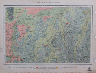
Map, Geological Survey of Victoria, 1913
... Geological Survey of Victoria...geological survey of victoria...Geological Survey of Victoria... Geological Survey of Victoria Printed colour map on paper victoria ...Printed colour map on papervictoria, geological survey of victoria, gladstone, talbot -
 Clunes Museum
Book, ROBERT S. BRAIN, BULLETINS OF THE GEOLOGICAL SURVEY OF VICTORIA, 1903
... BULLETINS OF THE GEOLOGICAL SURVEY OF VICTORIA...DEPARTMENT OF MINES, GEOLOGICAL SURVEY OF VICTORIA...BOOK - "BULLETINS OF THE GEOLOGICAL SURVEY OF VICTORIA... BULLETINS OF THE GEOLOGICAL SURVEY OF VICTORIA BOOK - "BULLETINS ...BULLETINS OF THE GEOLOGICAL SURVEY OF VICTORIA, AUSTRALIA.BOOK - "BULLETINS OF THE GEOLOGICAL SURVEY OF VICTORIA.. NO. 6 THE CLUNES GOLDFIELD BY W M. BRADFORD.non-fictionBULLETINS OF THE GEOLOGICAL SURVEY OF VICTORIA, AUSTRALIA.local history, mining, geological survey -
Koorie Heritage Trust
Book, Baragwanath, W, Memoirs of the Geological Survey of Victoria : No. 15 The Aberfeldy District, Gippsland, 1925
... Memoirs of the Geological Survey of Victoria : No. 15 The... -- Victoria. I. Geological Survey of Victoria. II. Victoria. Dept. of.... Geological Survey of Victoria. II. Victoria. Dept. of Mines ...15 v. : ill., plates, maps, plans, diagrs. ; 34 cm. lcsh: 1. geology -- victoria -- periodicals. 2. geology -- victoria. i. geological survey of victoria. ii. victoria. dept. of mines. -
 Federation University Historical Collection
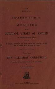
Book, William Baragwanath, Memoirs of the Geological Survey of Victoria No 14: The Ballarat Goldfield, 1923
... Memoirs of the Geological Survey of Victoria No 14: The...geological survey of victoria... Memoirs of the Geological Survey of Victoria No 14: The Ballarat ...257 page foolscap pink covered book relating to the Ballarat goldfields plus 32 plates of maps and sections. william baragwanath, mining, geological survey of victoria, ballarat, goldfields, raglan street, ballarat -
 Federation University Historical Collection
Book, Memoirs of the Geological Survey of Victoria No 11. The Maryborough Goldfield, 1913
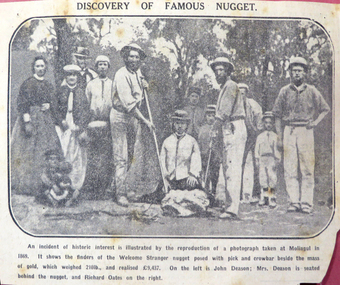
... Memoirs of the Geological Survey of Victoria No 11. The...memoirs of the geological survey of victoria... Memoirs of the Geological Survey of Victoria No 11 ...Pink soft covered book of 76 pages and 7 plates. Includes two loose newsclips .2) The Larkinville Nugget (The Age 21 Jan 1931) .3) Discovery of the Welcome Nuggetmaryborough, memoirs of the geological survey of victoria, d.j. mahony, maryborough goldfield, geology, faults, welcome nugget, richard oates, mrs deason, moliagul, larkinville nugget, m. larcombe, john deason, eucalypts -
 Federation University Historical Collection
Map, Ballaarat Gold Field, 1861
... by the Geological Survey of Victoria. In November 2004 the Central...Geological Survey of Victoria... by the Geological Survey of Victoria. In November 2004 the Central ...A party of surveyors camped by Yuille's Swamp (later Lake Wendouree) and surveyed the countryside for a map to be produced by the Geological Survey of Victoria. In November 2004 the Central Highlands Regional Library presented a special edition of 200 copies of the 1861 map reproduced from a copy in their collection. Original 1861 map of Ballarat showing streets and leads. Blue dots indicate gold leads, and red lines indicate auriferous quartz reef and outcrops of quartz veins."Compiled & Drawn from the Survey of Mining Surveyors Davidson, Fitzpatrick and Cowan & the Plans in the Surveyor General's Office by J. Brahe, 21st October 1861. R. Brough Smyth, Secretary for Mines. The Honourable J.B. Humffray, M.L.A. Commr of Mines.”ballarat, map, ballarat east, lake wendouree, survey, mines, robert davidson, ballarat gold field 1861, yuille's swamp, wendouree swamp, little bendigo diggings, gold leads, old post office hill, specimen hill, bakery hill, black hill, dead horse creek, brown hill, pennyweight hill, clayton hill, soldiers hill, golden point, gum tree flat, white flat, poverty hill, chinese village, robert brough smyth, ballarat map 1861, ballaarat vineyard, dead horse gully, deadhorse creek, invermay, black hill flat, gaelic church, police reserve, magpie range, dalton's flat, caadian lead, rifle butts, powder magazine, bathing house, government camp, gold office, chinese, llanberrris, victoria theatre, charlie napier hotel, united states hotel, grape's hoel, clayton's hill, cattleyard hill, free trade hotel, esmond lead, bakery hill, black hill lead, juvenile reformatory, ballarat orphanage, lady barkly lead, triffet's slaughter yard, little bendigo, melbourne road -
 Kiewa Valley Historical Society
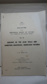
Document - Four Geological reports on the North-east Goldfields, Geological Survey of Victoria 1958 Bulletin
... Geological Survey of Victoria 1958 Bulletin...Geological Surveys of N.E. Goldfields Victoria included... Printer, Mines Department, Melbourne, Victoria Geological Surveys ...Geological Surveys of N.E. Goldfields Victoria included mines and tunnels. A resurvey of goldfields was necessary to re-assess economic possibilities using modern techniques and structural interpretation. It included an examination of a considerable surface area with maps and underground workings. Results were correlated and integrated and published by the Mines Department.The mines are in the Bogong Alpine Area.Foolscap printed Victorian Bulletins. Each stapled in the top left corner and each with varying number of pages. Covering 1941-1958 a) Glen Wills and Sunnyside b) Sunnyside Tunnel c) Red Robin d) Maud and Yellow Girl Government Printer, Mines Department, Melbourne, Victoriageology in the north-east, gold fields, goldmines, glen wills -
Tarnagulla History Archive
Bulletins of the Geological Survey of Victoria, no. 5 Dunolly Goldfield, 1903
... Bulletins of the Geological Survey of Victoria, no. 5... Survey of Victoria, no. 5 Dunolly Goldfield David Gordon ...David Gordon Collection. -
Tarnagulla History Archive
Bulletins of the Geological Survey of Victoria, no. 17 the Newbridge Goldfield, 1905
... Bulletins of the Geological Survey of Victoria, no. 17 the... Survey of Victoria, no. 17 the Newbridge Goldfield David Gordon ...David Gordon Collection. -
Tarnagulla History Archive
Bulletins of the Geological Survey of Victoria, no. 17 the Newbridge Goldfield, 1905
... Bulletins of the Geological Survey of Victoria, no. 17 the... Survey of Victoria, no. 17 the Newbridge Goldfield David Gordon ...David Gordon Collection. -
Tarnagulla History Archive
Records of the Geological Survey of Victoria, Vol. 3, Part 1, 1909
... Records of the Geological Survey of Victoria, Vol. 3, Part... Commercial Rd Tarnagulla goldfields Records of the Geological Survey ...David Gordon Collection. -
Tarnagulla History Archive
Records of the Geological Survey of Victoria, Vol. 3, Part 1, 1909
... Records of the Geological Survey of Victoria, Vol. 3, Part... Commercial Rd Tarnagulla goldfields Records of the Geological Survey ...David Gordon Collection. -
Tarnagulla History Archive
Records of the Geological Survey of Victoria, Vol. 3, Part 1, 1909
... Records of the Geological Survey of Victoria, Vol. 3, Part... Commercial Rd Tarnagulla goldfields Records of the Geological Survey ...David Gordon Collection. -
Tarnagulla History Archive
Records of the Geological Survey of Victoria, Vol. 4, Part 1, 1921
... Records of the Geological Survey of Victoria, Vol. 4, Part... Commercial Rd Tarnagulla goldfields Records of the Geological Survey ...David Gordon Collection. -
Tarnagulla History Archive
Records of the Geological Survey of Victoria, Vol. 4, Part 1, 1921
... Records of the Geological Survey of Victoria, Vol. 4, Part... Commercial Rd Tarnagulla goldfields Records of the Geological Survey ...David Gordon Collection. -
Tarnagulla History Archive
Records of the Geological Survey of Victoria, Vol. 4, Part 1, 1921
... Records of the Geological Survey of Victoria, Vol. 4, Part... Commercial Rd Tarnagulla goldfields Records of the Geological Survey ...David Gordon Collection. -
 Federation University Historical Collection
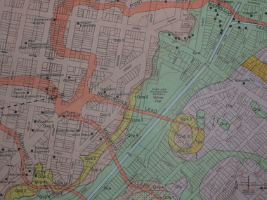
Plan, Ballarat Goldfield - Geological Survey of Victoria, 1981
... Ballarat Goldfield - Geological Survey of Victoria, 1981... Plan Ballarat Goldfield - Geological Survey of Victoria, 1981 ...Coloured geological plan showing the Ballarat goldfields. It includes coloured scales and nuggets from the Ballarat Goldfield. It also shows leads and mines.ballarat, geology, geological, gold nuggets, mining, mining companies, gold leads -
 Federation University Historical Collection
Book, Memoirs of the Geological Survey of Victoria No 14 The Ballarat Goldfields, 1923
... Memoirs of the Geological Survey of Victoria No 14 The... Book Memoirs of the Geological Survey of Victoria No 14 ...William Baragwanath was educated at the Ballarat School of Mines, obtaining a Geology Certificate in 1911. After further study he went on the become Secretary for Mines, and Chief Mining Surveyor. Baragwanath was a Councillor of the Ballarat School of Mine from 1916 to 1950.Pink covered foolscap book of 257 pages and 32 maps and plans by William Baragwanath. Contents include topography, physiography, historical, geology, basalt, faults, dykes, minerals leads, alluvial mines, nuggets, structure of Ballarat West goldfields, structure of Ballarat East gold-field, quartz formation, indicators, defunct mines, existing mines, table of deepest shafts. Images include: section of the Ballarat Gold-Field, Dead HOrse Flat, lakes formed by Basalt Flows, Gong Gong Creek, Frenchman's Lead, Ballarat West Mines, LEases and positions of shafts (1857), puddling, White Horse Lead, Woah Hawp Canton, Ballarat Township mines, Sebastopol, syncline, Victoria United Line, First Chance Mine, Llanberris No 1 Mine, Saddle Reef, New Normanby Mine, Woah Hawp Canton Mine, South Star Mine, Sebastopol Plateau, south Woah Hawp Mine, Woah No. 2 Minegeology, geological survey no 14, ballarat, baragwanath, william baragwanath -
 Federation University Historical Collection
Map - Geological, J. Phillips, Geological Survey of Victoria - Ballarat, 1857, 10/1858
... Geological Survey of Victoria - Ballarat, 1857... - Geological Geological Survey of Victoria - Ballarat, 1857 Geological ...Geological map of the Ballarat District featuring four colours.ballarat, geological, geology, geological plan -
 Federation University Historical Collection
Book, Stanley B. Hunter, Memoirs of the Geological Survey of Victoria No 7., The Deep Leads of Victoria, 1909
... Memoirs of the Geological Survey of Victoria No 7., The... Book Memoirs of the Geological Survey of Victoria No 7 ...Pink paper covered book by Stanley Hunter, Engineer in Charge of Boring Operations. Contents include tunnelling, deep sinking, the Chiltern Method, the Ballarat Method, Stawell, Ararat, Moyston, Raglan, Wimmera, Landsborough, Avoca, Ballarat West Leads, Berry-Moolort-Loddon Lead System, Clunes, Creswick, Bullarook Affluent, Corinella, Daylesford-Castlemaine Tributary, Majorca-Carisbrook tributary, Huntly, Coliban, Campaspe, Rutherglen., Smythesdale, Durham Lead, Tanjil, Evolution of Mining Machinery, size of claims, Definition of a Deep Lead, Discovery of Gold in Victoria, Geographical Position of Deep Leads, Water in Deep Leads, Methods of Deep Lead Mining, Cost of Deep Lead Mining, Stawell, Ararat, Moyston, Raglan, Wimmera, Landsborough, Avoca, Ballarat West, Berry, Springs Hill, Loddon Valley, Charlotte Plains, , Timor, Burn Creek, Huntly, Colinan, Goulburn, Ovens Valley, Chiltern, Indigo, Morrison's Lead, Plans include: geological Map of Stawell, ararat, Raglan and Landsborough; Kempson's Freehold Mine, Stawell; Geological Map of Beaufort, Avoca, Maryborough, Ballarat west, Berry-Moolort, Loddon, Creswick, Marong, &c; Cardigan Propriety Gold Mine; Working Miners United Gold Mine, Homebush; Hepburn Deep Lead Plan; Madame Berry West Mine; West Berry Consols Mine; Spring Hill and Central Leads; Berry Consols Extended Mine; Loddon Valley Goldfields; Chalk's No 3 Mine; Charlotte Plains Considated Mine; Duke United Mine; Geological Map of Bendigo, Huntley, Campaspe, Malmsbury, Kyneton, trentham, &c; Geological Map of Chiltern, Rutherglan, Eldorado, Beechworth, &c; Chiltern Valley Gold Mine; Wallace Chiltern Valley Consols Mine; great Southern and Chiltern Valley United Mine; great Northern extended Consols; Prentice and Southern deep Leads; Glenfine South Gold Mine; Geological map of Pitfield, Rokewood, Mt Mercer, Ballark, Meredith, &c.; McEvoy Mine; Dargo . . . . . . . . . . . . . . . . . . . . . . . mining, deep leads, squire, tools, gold panning, gold cradle, cradling, puddling, tubbing, mining shaft, shaft sinking, whip, horse whip, whim, horse whim, chalk's no. 1 mine, maryborough, mining cage, shaft, mining trucks, maryborough, washdirt, puddler, tunnelling, deep sinking, chiltern method of working, ballarat method of working, sampling washdirt. gravels, balmoral, mt william, stawell, moyston, great western, ararat, raglan, wimmera valley, landsborough, cardigan, haddon, beaufort, waterloo, avoca, lamplough, caralulup, ballarat west, ballarat, smythesdale, glenfine, illabarook, durham lead, morrison's lead, bullengarook, berry-moolort-loddon system, clunes, creswick, spring hill, bullarook, castlemaine - daylesford, majorca, carisbrook, timor, burnt creek tributary, tarnagulla, marong, rheola, inglewood, huntly, coliban, campaspe, goulburn lead system, ovens valley system, mitta mitta, kiewa valley, tarago, tanjil, moondarra, bogong, dargo high plains -
 Stawell Historical Society Inc
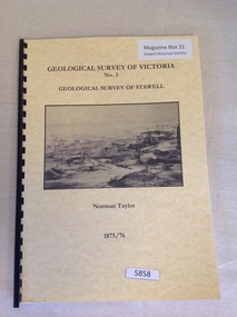
Book, Norman Taylor, Geological Survey of Victoria No3, Geological Survey of Stawell, 1875-1876
... Geological Survey of Victoria No3, Geological Survey of... grampians Book Geological Survey of Victoria No3, Geological Survey ...stawell mining -
Stawell Historical Society Inc
Archive, Geological Survey of Victoria 1903 Brown Cover, 1903
... Geological Survey of Victoria 1903 Brown Cover... grampians Archive Geological Survey of Victoria 1903 Brown Cover ...1903 Brown Coverstawell, mining -
 Federation University Historical Collection
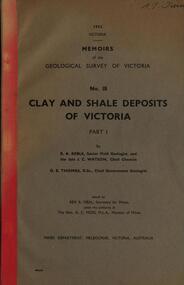
Book, Memoirs of the Geological Survey of Victoria; No 18, Clay and Shale Deposits of Victoria, 1952
... Memoirs of the Geological Survey of Victoria; No 18, Clay...Book Memoirs of the Geological Survey of Victoria; No 18 ...Grey soft covered book with red tape spine. The 76 pages clay deposits, composition of Victorian clays, clay localities, granitic clays, Residual Clays, Clay-Shales, Jurassic clay shales.r a keble, senior field geologist, j c watson, chief chemist, d e watson, chief government geologist, g c moss, minister of mines, mallee plains, avoca valley, loddon valley, campaspe valley, goulburn valley, kiewa, mitta, glenelg valley, pitfield valley, otway area, moorabool valley, darley fireclay, campbellfield clay, latrobe river valley, hendley, ball clays, felspars, pegmatities, quartz, pakenham fireclay, bulla china clay, kaolin, terracotta, stoneware, ballan dyke-belt, egerton, gordon, ballan, llandeilo, colbrook, elaine, lal lal, maryborough, ballarat, ringwood, siliceous clay, stawell, dromana, ptways, bulla, pyalong china clay, linton china clay, wedderburn clays, lal lal china clays, ballan dyke belt, reginald callister, knight's koalin pottery, china clay, ferdinand krause, clarendon, bittern, frichot, hunt's dam, vaughan, rosenow, hickey, malone, claypits, ballarat dyke belt, stawell dyke belt, maryborough dyke belt, guildford, daylesford, ovens valley -
 Federation University Historical Collection
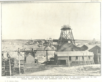
Book, J.W. Gregory, Memoirs of the Geological Survey of Victoria No. 4: The Ballarat East Gold-Field, 1907
... Memoirs of the Geological Survey of Victoria No. 4: The...Book Book Memoirs of the Geological Survey of Victoria ...Blue soft covered report with 40 plates and plans. Inciudes Geology of Ballarat. Little Bendigo Goldfield, Ballarat West Goldfield, Ballarat East Goldfield, history, nuggets, indicators, faults, microscopic structure of Ballarat Rocks and ores, general type of the Ballarat East Mines and the genesis of their ores. Mines include New Zealand Trust, Llanberris No. 1, Llanberris No 2, Victoria United, Britannia United, New Britannia, Last Chance, Exchange, Normanby North, New Normanby, North Woah Hawp. Photpgraphic plates include: Victoria United Mine, Llanberres No. 1, Normanby North, North Woah Hawp Mine, View looking south from the Britannia Mullock Heap, View from Sovereign Hill, The place in Learmonth Street Golden Point where gold was first discovered at Ballarat. j.w. gregory, ballarat east, ballarat east goldfield, e.j. dunn, geolological survey of victoria, new zealand trust, llanberris no. 1, llanberris no 2, victoria united, britannia united, new britannia, last chance, exchange, normanby north, new normanby, north woah hawp, mining, indicators, gold mining, poppet head -
Federation University Historical Collection
Map - Map - Geological, Geological Survey of Victoria - Ballarat, 09/1858
... Geological Survey of Victoria - Ballarat...Map - Geological Map Geological Survey of Victoria ...Coloured Geological Map of Ballarat, edged with masking tape. The map show alluvial silt, gold drift, geological orders, volcanic, and gold workings. Scale is 8 chains to an inch. WGS 84 Centroid: 37 degrees 33 feet 33 inches south 143 degrees 52 feet 02 inches east W.E. extent: 5km NS extent: 3 kmballarat, ballaarat, geology, goldfield, phillips, j. phillips, mining -
 Wodonga & District Historical Society Inc
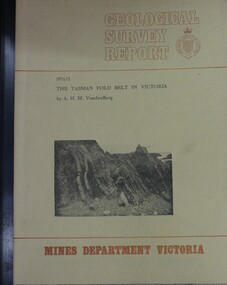
Booklet - The Tasman fold belt system in Victoria : geology and mineralisation of proterozoic to carboniferous rocks, A.H.M. Vanden Berg, 1976
... Geological Survey of Victoria.... A.H.M. Vanden Berg Geological Survey of Victoria Dept ...A scientific analysis of the development of the sequence of geological events and processes which contributed to the building of southeastern Australia landforms as part of the Tasman Fold Belt System.non-fictionA scientific analysis of the development of the sequence of geological events and processes which contributed to the building of southeastern Australia landforms as part of the Tasman Fold Belt System.geology victoria, landforms victoria, tasman fold belt -
 Federation University Historical Collection
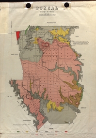
Map - Plan, E.J. Dunn, Bungal County of Grant Parish Plan
... Geological Survey of Victoria.... Dunn Geological Survey of Victoria State Regional Boundaries ...E.J. Dunn was tje surveyor of this parish plan.Colour geological plan of Bungal in the County of Grant, Victoria. The areas circled in red ar craters.plan, bungal, bungeltap, black horse co. egerton, egerton, mount egerton, sister rose shaft, south learmonth co, kerrit bareet, bungaeeltap, yaloak, eastern moorabool river, corong, bungal station preemptive right, lal lal, western moorabool river, moorabool rover, borhoneychurck, mount egerton battery, bungal creek -
 Federation University Historical Collection
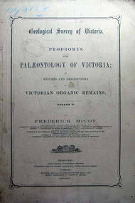
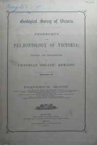
Book, Prodromus of the Palaeontology of Victoria, 1877 (exact)
... geological survey of victoria... Survey of Victoria. Illustrations, plates in b/w; 41 p... page. At head of title: Geological Survey of Victoria ...This publication consists of many Decades which contain "figuers and descriptions of the fossil organic remains to be used for the determination of the geological ages of the different geological formations of the country." (p. 3). Frederick McCoy was born in Dublin, Ireland in 1817. He was a Professor of Natural Sciences, University of Melbourne 1854-1899. McCoy lectured in geology, zoology, chemistry, mineralogy, geography and botany. In 1858 He became the Director of the National Museum of Victoria and the President of the Royal Society of Victoria in 1864. In 1888, McCoy was awarded FRS for work in Palaeontology in Ireland, England and Australia. He died in his office while correcting examination papers in 1899.A Paperback cover book. Decade v. Title is written in black on front cover and on title page. At head of title: Geological Survey of Victoria. Illustrations, plates in b/w; 41 p. It includes figures and descriptions of Victorian Organic Remains and contents of Decades on back cover.Stamped Ballarat East Public Library"australia palaeobotany, victoria palaeontology, geological survey of victoria, frederick mccoy, organic remains, ballarat east library, ballarat east public library -
 Federation University Historical Collection
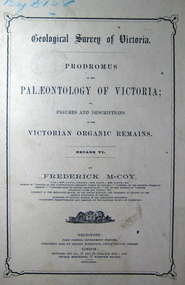
Book, John Ferres, Government Printer, Prodromus of the Palaeontology of Victoria Decade vi, 1878 (exact)
... geological survey of victoria...: Geological Survey of Victoria. Illustrations, plates in b/w; 42 p... victoria palaeontology geological survey of victoria frederick ...This publication consists of many Decades which contain "figuers and descriptions of the fossil organic remains to be used for the determination of the geological ages of the different geological formations of the country." (p. 3). Frederick McCoy was born in Dublin, Ireland in 1817. He was a Professor of Natural Sciences, University of Melbourne 1854-1899. McCoy lectured in geology, zoology, chemistry, mineralogy, geography and botany. In 1858 He became the Director of the National Museum of Victoria and the President of the Royal Society of Victoria in 1864. In 1888, McCoy was awarded FRS for work in Palaeontology in Ireland, England and Australia. He died in his office while correcting examination papers in 1899.A Paperback cover book. Decade VI. Title is written in black on front cover and on title page. At head of title: Geological Survey of Victoria. Illustrations, plates in b/w; 42 p. It includes figures and descriptions of Victorian Organic Remains and contents of Decades at back of the book.australia palaeobotany, victoria palaeontology, geological survey of victoria, frederick mccoy, organic remains, john ferres -
 Federation University Historical Collection
Book, Prodromus of the Palaeontology of Victoria No iv, 1876 (exact)
... geological survey of victoria...: Geological Survey of Victoria. Illustrations, plates in b/w; 32 p... and on title page. At head of title: Geological Survey of Victoria ...This publication consists of many Decades which contain "figuers and descriptions of the fossil organic remains to be used for the determination of the geological ages of the different geological formations of the country." (p. 3). Frederick McCoy was born in Dublin, Ireland in 1817. He was a Professor of Natural Sciences, University of Melbourne 1854-1899. McCoy lectured in geology, zoology, chemistry, mineralogy, geography and botany. In 1858 He became the Director of the National Museum of Victoria and the President of the Royal Society of Victoria in 1864. In 1888, McCoy was awarded FRS for work in Palaeontology in Ireland, England and Australia. He died in his office while correcting examination papers in 1899A Paperback cover book. Decade IV. Title is written in black on front cover and on title page. At head of title: Geological Survey of Victoria. Illustrations, plates in b/w; 32 p. It includes figures and descriptions of Victorian Organic Remains and contents of Decades on the back cover of the book.australia palaeobotany, victoria palaeontology, geological survey of victoria, frederick mccoy, organic remains